TROPICAL ATLANTIC SATELLITE LOOP

TROPICAL CYCLONE DANGER AREAS

LIVE, REAL-TIME, TEXAS ROAD CONDITIONS.
SHOWS FLOODING, TRAFFIC, CONSTRUCTION,
AND OTHER ROAD CONDITIONS
http://drivetexas.org
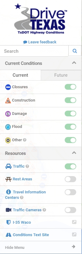
USE "SWITCHES" ON MENU ON RIGHT SIDE OF MAP TO TURN FEATURES ON OR OFF
USE the "+" (PLUS) or "-" (MINUS) TO ZOOM MAP IN AND OUT.
MAP CAN BE SEARCHED AND SCROLLED
MENU CAN BE CLOSED BY CLICKING ON "HIDE MENU" AT BOTTOM OF THE MENU
CLICKING ON A HIGHLIGHTED ROAD WILL DISPLAY ADDITIONAL INFORMATION
SAMPLE OF PART OF DRIVETEXAS.ORG MAP SHOWING LOCAL TRAFFIC AND FLOODED ROADS
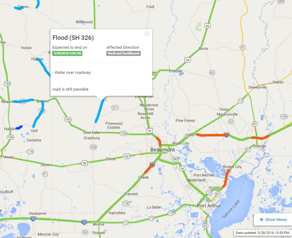
EXAMPLE OF DRIVETEXAS.ORG DISPLAY
MENU
DRIVETEXAS.ORG IS EXTREMELY USEFUL ON MOBILE DEVICES!
(SEE IMAGE BELOW)
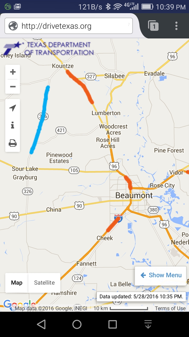
ON THE MAP (above) THE ROAD IN BLUE IS FLOODED OR HAS WATER OVER THE ROAD
ROADS HIGHLIGHTED IN RED ARE HEAVILY CONGESTED
LOCAL TEMPERATURES, WIND, RADAR, SATELLITE, and PRECIPITATION MAPS
Interactive Maps From GOOGLE and WEATHERUNDERGROUND
CLICK HERE TO VIEW INTERACTIVE LOCAL PRECIPITATION MAP
(opens in new tab or window)
CLICK HERE TO VIEW INTERACTIVE LOCAL RADAR MAP
(opens in new tab or window)
ANIMATED TEXAS RADAR LOOP

COLOR ENHANCED TEXAS - LOUISIANA AREA IMAGE

UPDATED EVERY 15 MINUTES
ANIMATED GULF IR FROM GOES NOAA

ANIMATED GULF WATER VAPOR IMAGE FROM NOAA

Eastern Gulf, Florida, SE U.S. Composite Radar Loop

GULF IR IMAGE

Mississippi Valley and Central Gulf Composite Radar Loop
EMERGENCY MANAGEMENT MAGAZINE PUBLISHES A TEXAS CENTRIC
ARTICLE ON ASSEMBLING AN EMERGENCY KIT
ASSEMBLING AN EMERGENCY KIT
ATLANTIC COLOR COMPOSITE IMAGE - ANIMATED

Global Tropics Benefits/Hazards Assessment
Shows what may be developing over the next two weeks
From the National Hurricane Center,
these assessments project global tropical weather for the next two weeks.
According to the NHC:
The Global Tropics Hazards and Benefits Assessment
provides an outlook for the upcoming 1 to 2 week time period
for areas expecting enhanced or suppressed rainfall integrated
over a week and regions where conditions are especially favorable
or unfavorable for tropical cyclogenesis.
The anomalous rainfall outlooks target broad-scale conditions
and local conditions will vary.

Most Recent GOES USA East Medium-Resolution Image

SOURCE: NOAA-NASA GOES Project
LATEST WESTERN HEMISPHERE GOES IMAGE
SHOWS STORMS COMING OFF AFRICAN COAST
AND TRACKING ACROSS ATLANTIC

FULL DISK MOVIE
SHOWS STORMS TRACKING FROM AS FAR AWAY AS AFRICA
LARGE VIDEO FILE (12mb) IN MP4 FORMAT
SOURCE: NOAA-NASA GOES Project
OTHER VIDEOS, AND LARGER IMAGES AVAILABLE FROM NOAA
>
ANIMATED TEXAS RADAR LOOP
ANIMATED RADAR IMAGE FOR FLORIDA AND SE US COAST
GULF IR SATELLITE AND RADAR
Mississippi Valley and Central Gulf Composite Radar Loop
Eastern Gulf, Florida, SE U.S. Composite Radar Loop
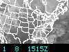
NATIONAL WEATHER MAPS
TODAY'S FORECAST

TOMORROW'S FORECAST WEATHER MAP

THREE DAY FORECAST FORECAST WEATHER MAP

CURRENT COLOR ENHANCED NATIONAL WATER VAPOR SATELLITE IMAGE
Also shows winds

US WATER VAPOR Image
Shows winds
Updated every 30 minutes
East Conus Water Vapor Loop
High resolution animated composite water vapor map
Carribean Color Enhanced Tropical Composite
From the US Navy
LONG TERM WEATHER PREDICTIONS
6 to 10 Day Temperature Outlook

6 to 10 Day Precipitation Outlook

Composite Weather Threats

8 to 14 Day Outlook
(Click on link to display predictions)
8 to 14 Day Temperature Outlook
8 to 14 Day Precipitation Outlook
30 Day Outlook
(Click on link to display predictions)
30 Day Temperature Outlook
30 Day Precipitation Outlook
90 Day Outlook
(Click on link to display predictions)
90 Day Temperature Outlook
90 Day Precipitation Outlook

National Hurricane Center Storm Surge Overview
FEMA STORM SURGE MAPS FOR SE TEXAS AND SW LOUISIANA
FEMA STORM SURGE MAP FOR JEFFERSON COUNTY (PDF)
FEMA STORM SURGE MAP FOR ORANGE COUNTY (PDF)
FEMA STORM SURGE MAP FOR HARDIN COUNTY (PDF)
FEMA STORM SURGE MAP FOR JASPER COUNTY (PDF)
FEMA STORM SURGE MAP FOR NEWTON COUNTY (PDF)
FEMA STORM SURGE MAP FOR SAINT MARY PARISH (PDF)
FEMA STORM SURGE MAP FOR Calcasieu Parish (PDF)
FEMA STORM SURGE MAP FOR JEFFERSON DAVIS PARISH (PDF)
FEMA STORM SURGE MAP FOR ACADIA PARISH (PDF)
FEMA STORM SURGE MAP FOR LAFAYETTE PARISH (PDF)
FEMA STORM SURGE MAP FOR SAINT MARTIN PARISH (PDF)
FEMA STORM SURGE MAP FOR CAMERON PARISH (PDF)
FEMA STORM SURGE MAP FOR VERMILLION PARISH (PDF)
FEMA STORM SURGE MAP FOR IBERIA PARISH (PDF)
COASTAL RISK ATLAS
Interactive maps about coastal vulnerabilities
Hurricane Wind Risks
Interactive maps and charts from the National Hurricane Center
South East Texas Info
South East Texas Evacuee Information Site
This site is intended for the use of Jefferson, Hardin and Orange County Residents
2018 (LATEST) SOUTHEAST TEXAS INLAND Evacuation Map (PDF File)
FROM TXDPS, RIGHT CLICK and select "SAVE LINK AS"
South East Texas Emergency Management Contact Information
2018 (South East Texas Inland Evacuation Map (PDF File)
FROM TXDOT, RIGHT CLICK and select "SAVE LINK AS"
2018 HOUSTON AREA Inland Evacuation Map (PDF File)
FROM TXDOT, RIGHT CLICK and select "SAVE LINK AS"
2018 STATEWIDE (TEXAS) Inland Evacuation Map (PDF File)
FROM TXDOT, RIGHT CLICK and select "SAVE LINK AS"
OFFICIAL TEXAS DEPARTMENT OF TRANSPORTATION (TxDOT)
HURRICANE INFORMATION AND EVACUATION SITE
INCLUDES ALL OF THE OFFICIAL EVACUATOPM MAPS
TxDOT STATEWIDE CONTRAFLOW LANES
I-10, I-45, US 290, US 59, I-37, US 83/281, Rio Grande Area
EVACUATION INFORMATION FOR TEXANS WITH SPECIAL NEEDS
Call 2-1-1 If You Need a Ride or other evacuation assistance
PETS- EVACUATING WITH YOUR PETS
DPS Guide for evacuating with your pets
Register IN ADVANCE for a Ride 2-1-1 FLYER (PDF)
Southeast Texas Alert Network (STAN)
This system allows local emergency management officials and industry leaders in
Jefferson, Hardin and Orange Counties to share information directly with the public
via telephone and text message during emergency events occurring in Southeast Texas.
Please register your information to ensure that you receive these important messages.
Hurricane Season Preparedness
Hurricane Preparedness Guide from BounceEnergy
YouTube Video - Hurricane Preparedness Tips for Gulf Coast Residents from BounceEnergy
PDF - HOW HURRICANES IMPACT YOU - INFOGRAPHIC From BounceEnergy
GULF COAST HURRICANE PREPAREDNESS GUIDE
NOAA TEXAS EXTREME WEATHER INFORMATION SHEET (Revised 2018) - PDF
NOAA LOUISIANA EXTREME WEATHER INFORMATION SHEET (Revised 2018) - PDF
There are Seperate Extreme Weather Sheets or SE and SW Louisiana
HURRICANE GUIDE FOR SE TEXAS - PDF
Large Download (30mb) - An EXCELLENT and COMPREHENSIVE Resource
HURRICANE GUIDE FOR SW LOUISIANA - PDF
Large Download (17mb) - An EXCELLENT and COMPREHENSIVE Resource
HURRICANE GUIDE FOR HARRIS COUNTY AND SURROUNDING COUNTIES - PDF
HARRIS COUNTY EVACUATION INFORMATION
This page will be updated as conditions dictate
BE SURE TO CLICK ON "RELOAD" OR "REFRESH" FOR THE LATEST INFORMATION
CURRENT COLOR ENHANCED
NATIONAL IR SATELLITE IMAGE

US IR Image
Updated every 30 minutes

Click on small image above to load
LARGE NATIONAL ANIMATION
CURRENT REGIONAL CONDITIONS AND TR NDS

Click on image above for NATIONAL and REGIONAL surface conditions
CURRENT SURFACE CONDITIONS IN THE GULF OF MEXICO
Click on the image above for additional information about the symbols used and their meanings.
In this sample (above) the wind is blowing FROM the northwest at 15 knots, moderate rain, temperature is 57F,
dew point 56F, sky cover - clear, barometric pressure is 1010.7mb, down 0.6mb in the last 3 hours.
CLICK FOR PRINTER FRIENDLY VERSION OF THE SYMBOLS
OFFSHORE WEATHER, WAVES, AND WATER CONDITIONS
GULF OFFSHORE WEATHER FORECAST, WAVE, AND WATER CONDITIONS
ATLANTIC AND CARIBBEAN OFFSHORE WEATHER AND WATER CONDITIONS
From the National Weather Service Tropical Analysis and Forecast Branch
Several people have emailed me asking how to print or save ONLY selected images;
it is EASY. Simply RIGHT CLICK on the image and then from the window that opens
left click on "PRINT PICTURE" or "SAVE PICTURE"
MOST OF THE LINKS ON THIS PAGE ARE DESIGNED TO OPEN IN A NEW WINDOW.
NOTE: According to the FORECAST page at the Lake Charles Weather Service:
"Short Term Forecast: An event-driven, 1- to 6-hour weather forecast for the above area,
issued only when conditions warrant.
(Use with caution, as this product may be out of date)"
DETAILED FORECAST FOR JEFFERSON COUNTY
DETAILED FORECAST FOR ORANGE COUNTY
DETAILED FORECAST FOR CALCASIEU PARISH
CURRENT CONDITIONS AT LAKE CHARLES REGIONAL AIRPORT (LCH)
CURRENT OFFSHORE CONDITIONS, TX AND LA GULF COAST
INTERACTIVE MAP
OFFSHORE REALTIME WEATHER FROM RIG, 30 MILES SE OF SABINE PASS
TIDES - SE TEXAS AND SW LOUISIANA
CURRENT FIRE CONDITIONS IN SE TEXAS AND SW LOUISIANA
INTERACTIVE MAP
NOAA and other Government Hurricane and Emergency Publications
HURRICANE BASICS FROM NOAA
Comprehensive hurricane information from NOAA in PDF format
PREPARING FOR A STORM
Comprehensive storm planning information from Texas Emergency Management
EMERGENCY PREPAREDNESS
Comprehensive storm, evacuation, and other disaster information from Texas Emergency Management
DIABETES CARE DURING EMERGENCIES AND EVACUATION
PDF From BD, a detailed list of things for a DIABETIC
to prepare for before and during an evacuation
HURRICANE READINESS Compiled by the City of Corpus Christi
Hurricane Resources
From the EMERGENCY EMAIL AND WIRELESS NETWORK
HURRICANE PREPAREDNESS BROCHURE
EXCELLENT AND COMPREHENSIVE INFORMATION FROM THE NYC
OFFICE OF EMERGENCY MANAGEMENT
Southeast Texas Evacuation Map (revised 2009) - PDF
(See the 2011 TXDOT maps below for updated maps)
OFFICIAL CITY OF BEAUMONT EMERGENCY MANAGEMENT WEBSITE
Includes evacuation information, transportation to shelters, and other city information
OFFICIAL CITY OF BEAUMONT 2011 HURRICANE PREPAREDNESS GUIDE
Includes evacuation information, transportation to shelters, and other city information
OFFICIAL CITY OF BEAUMONT 2011 HURRICANE ASSEMBLY POINTS
For Beaumont residents who need evacuation transportation
Call 211 IN ADVANCE to arrange evacuation transportation
OFFICIAL EVACUATION ROUTES
JEFFERSON, ORANGE and CHAMBERS COUNTIES
PDF FILE
ALSO SHOWS FLOOD ZONES
OFFICIAL SE TEXAS EVACUATION MAP (PDF)
OFFICIAL SW LOUISIANA EVACUATION MAP (PDF)
Disaster Preparedness Planning Packet for Special Needs Populations
PDF file from the Lamar University School of Nursing
Preparing for Emergencies in Jefferson County
American Red Cross - Jefferson County Chapter
TEXAS EMERGENCY MANAGEMENT (TXDPS) SABINE AREA HURRICANE STUDY
PDF file of hurricane information and evacuation routes for SE Texas from Galveston Bay to Orange
TEXAS EMERGENCY MANAGEMENT (TXDPS) GALVESTON/HOUSTON AREA HURRICANE STUDY
PDF file of hurricane information and evacuation routes
OFFICIAL TxDOT and DPS EVACUATION MAP FOR SOUTHEAST TEXAS
Includes Dayton, Liberty, Anahuac, Beaumont, Port Arthur, and Orange.
This map is in PDF format and can be saved AND SHOULD BE PRINTED FOR EMERGENCY USE!
DIRECTORY OF EVACUATION MAPS FROM TxDOT
Includes Beaumont, Houston, Corpus Christi, Pharr, Yoakum, Entire Coast, and more...
TxDOT EVACUATION ROUTES FOR BEAUMONT and SE TEXAS (JPG FORMAT)
TxDOT EVACUATION ROUTES FOR BEAUMONT and SE TEXAS (PDF FORMAT)
TxDOT EVACUATION ROUTES FOR ENTIRE TEXAS COAST (JPG Format)
TxDOT EVACUATION ROUTES FOR ENTIRE TEXAS COAST (PDF Format)
TxDOT EVACUATION ROUTES FOR HOUSTON and GALVESTON AREAS (JPG Format)
TxDOT EVACUATION ROUTES FOR HOUSTON and GALVESTON AREAS (PDF Format)
I-45 EVACUATION MAP FROM HOUSTON to DALLAS (PDF)
I-10 EVACUATION MAP FROM HOUSTON to SAN ANTONIO (PDF)
US 290 - Houston to Austin, Bryan, College Station, Waco (PDF)
US 59 - Houston to Nacogdoches (PDF)
TxDOT EVACUATION ROUTES FOR CORPUS CHRISTI (JPG FORMAT)
TxDOT EVACUATION ROUTES FOR CORPUS CHRISTI (PDF FORMAT)
IH 37 - Corpus Christi to San Antonio (PDF)
Hurricane Maps and Brochures - TXDPS Division of Emergency Management
Area maps, Area Hurricane Information, and Local Evacuation Maps
For Sabine, Galveston/Houston, Matagorda, Coastal Bend, and Valley regions
Hurricane Planning Materials - TXDPS Division of Emergency Management
TxDOT INTERACTIVE ROAD CONDITIONS
JEFFERSON COUNTY EMERGENCY MANAGEMENT
JEFFERSON COUNTY EMERGENCY MANAGEMENT
HURRICANE INFORMATION
STORM SURGE (Salt Water Intrusion) MAP FOR SOUTHEAST TEXAS
From KFDM Channel 6
Mouse over a storm category to see the storm surge impact.
REALTIME AIRPORT WEATHER CONDITIONS AND FLIGHT DELAYS
FROM THE WEATHER CHANNEL
http://www.weather.com/activities/travel/dailytraveler/index.html
TROPICAL WEATHER
LATEST HURRICANE AND TROPICAL STORM REPORTS
Includes detailed strike probabilities
FROM NOAA - IWIN (Interactive Weather Information Network)
TROPICAL WEATHER OUTLOOK
Direct from the National Hurricane Center
HISTORICAL HURRICANE TRACKS
and other historical tropical data, including coastal population trends
HISTORICAL GRAPH - JEFFERSON COUNTY POPULATION vs HURRICANE HITS
Historical population and hurricane strike data for other coastal counties and parishes
DETAILED STRIKE PROBABILITIES FOR OTHER CITIES
STORM CENTERED TROPICAL RADAR LOOP
From Intellicast
Realtime monitoring of tropical Atlantic conditions from NOAA
HURRICANE ALLEY IR
NOW UPDATED EVERY HALF-HOUR
ANIMATION OF IR IMAGE (ABOVE)
This is a LARGE file, and uses JAVA,
which will work on MOST of the newer browsers
HURRICANE ALLEY WATER VAPOR
Shows winds
UPDATED HOURLY
JAVA ANIMATION OF HURRICANE WATER VAPOR
The animation is a LARGE file
ANIMATION OF WATER VAPOR IMAGE (ABOVE)
This is a LARGE file, and uses JAVA,
which will work on MOST of the newer browsers
If you seem to get "old" weather after clicking on a site that you have used before, you should
click on the "RELOAD" or "REFRESH" button of your browser. Sometimes the "old" weather is stored in your disk cache!
WEATHER CALCULATORS
WEATHER CALCULATOR - NWS EL PASO
Includes calculations and conversions for temperature, wind, humidity, pressure, and other items
OTHER CURRENT INFORMATION
LOCAL WEATHER DETAILS
Direct from the National Weather Service
24 HOUR SURFACE FORECAST MAP
Current Conditions, Forecasts, Watches and Warnings for Jefferson County
Direct from NWS
DETAILED TEXAS INFORMATION - NWS
DETAILED LOUISIANA INFORMATION - NWS
SOUTH CENTRAL US LIGHTNING MAP From Intellicast
CURRENT WATCHES - TEXAS STATEWIDE Direct from NOAA
SPECIAL WEATHER STATEMENTS - TEXAS Direct from NOAA
TEXAS SEVERE WEATHER STATEMENT
CURRENT - - FOR LOUISIANA (by PARISH)
CLICK on PARISH for report
TEXAS WEATHER REPORT - UPDATED HOURLY Direct from NOAA
SEVERE THUNDERSTORM WARNINGS for TEXAS Direct from NOAA
SEVERE THUNDERSTORM WARNINGS for LOUISIANA Direct from NOAA
FLASH FLOOD AND FLOOD WARNINGS for TEXAS Direct from NOAA
FLOOD STATEMENTS for TEXAS Direct from NOAA
NOAA NATIONAL FLOOD INFORMATION
TEXAS TORNADO WARNINGS
SEVERE STORM OUTLOOK
CURRENT TORNADO AND SEVERE THUNDERSTORM WARNINGS
SEVERE WEATHER SAFETY
NWS FIRE WEATHER - SE TEXAS and SW LOUISIANA
NWS INTERNET WEATHER SERVICE
VERY comprehensive internet weather information
COMPOSITE NATIONAL RADAR
Current, 6 hour, and 12 hour loops, NWS/NOAA
Southern Regional Climate Center - LSU
Houston Chronicle - Weather Page SEVERE WEATHER WARNINGS
TCEQ Beaumont-Port Arthur-Orange AIR POLLUTION
CURRENT POLLEN AND AIR POLLUTION MAPS
TCEQ - Current Texas State Air Pollution
OZONE ACTION DAYS - From the TCEQ
U.S. Weather Threats Assessment
LATEST ATLANTIC HURRICANE NEWS
ALL CURRENT WARNINGS - TEXAS Direct from NOAA
ALL CURRENT WARNINGS - LOUISIANA Direct from NOAA
CLIMATOLOGICAL REPORT (DAILY) - TEXAS Direct from NOAA
PUBLIC STATEMENTS FROM NOAA - TEXAS
RIVER AND OTHER HYDROLOGICAL DATA - TEXAS
WESTERN GULF RIVER FORECAST CENTER - NOAA
NATIONAL STORM PREDICTION CENTER
MAP of SEVERE STORM WARNINGS and WATCHES
From National Severe Storms Laboratory
Texas Non Precipitation Warnings
TEXAS WINTERSTORM WARNINGS
Current TEXAS conditions Very comprehensive
LOCAL CONDITIONS - US INTERACTIVE WEATHER MAP
WEATHER BULLETINS AND SEVERE WEATHER IN SE TEXAS
From the NWS Houston-Galveston office
TROPICAL WEATHER STATEMENTS AND INFORMATION
NWS Houston
CURRENT UV (Ultra Violet) HEALTH RISK
SE TEXAS OZONE CONDITIONS
Local and statewide from the TCEQ (Updated address)
STATEWIDE ROAD AND HIGHWAY CONDITIONS
CURRENT ROAD CONDITIONS IN JEFFERSON COUNTY
CURRENT ROAD CONDITIONS I-10
CURRENT ROAD CONDITIONS - ORANGE COUNTY
ROAD CONDITIONS - ALL TEXAS COUNTIES
All the above from TxDOT
CURRENT CONDITIONS ON I-10
Jacksonville, FL - Los Angeles, From Intellicast
CURRENT ROAD AND HIGHWAY CONDITIONS - Nationally
Interactive Map From Intellicast
BEAUMONT Radar WEATHER FORECAST
Shows storms' course and speed (new address)
Beaumont PRECIPITATION Weather Radar
Shows rainfall amounts over past 24 hours- NEW address
TEXAS PRECIPITATION Weather Radar
Shows rainfall amounts over past 24 hours- NEW address
TEXAS RADAR WEATHER FORCAST
Shows storms' course and speed (new address)
INTERACTIVE WEATHER INFORMATION FROM NWS
Updated every 5 minutes
WORLDWIDE INFRARED COMPOSITE
The entire global weather in a glance
Current NATIONAL NEXRAD
Shows intensity, course and speed of storms
Southeast Texas FIRE Forecast
Climatic Summary For Beaumont / Port Arthur
TEXAS WEATHER DETAILS
Includes warnings, etc.
TEXAS NEXRAD
From INTELLICAST - NEW address
Hurricane SECTOR IR Image
Click on thumbnail above for FULL Image
NATIONAL IR SATELLITE
Click on thumbnail above for FULL Image
CURRENT NATIONAL RADAR COMPOSITE
Interactive Map - Click for local NEXRAD
CURRENT SEA TEMPERATURES
Click on thumbnail above for FULL Image
GULF OF MEXICO SEA SURFACE TEMPERATURES - Color Composite
From the US NAVY
SEA SURFACE TEMPERATURE ANIMATIONS (Directory)
These may be large files, and include current and historical graphics and animations
Animation of Atlantic Sea Surface Temperatures Covers most recent 12 weeks
Animation of "HURRICANE ALLEY" Infra Red (IR) for past 4 days
This shows storms from African coast to the Gulf of Mexico
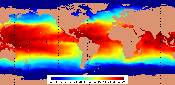
ATLANTIC SEA SURFACE TEMPERATURES
From the US Navy
SEA SURFACE TEMPERATURES - NOAA
For HURRICANE ALLEY and the GULF OF MEXICO

COLOR ENHANCED ATLANTIC UPDATED HOURLY
CLICK FOR FULL IMAGE
ANIMATION OF COLOR ENHANCED IR IMAGE (ABOVE)
This is a LARGE file, and uses JAVA,
which will work on MOST of the newer browsers

INFRARED ATLANTIC UPDATED HOURLY
CLICK FOR FULL IMAGE